Ridgecrest Intermediate map: RIS campus map
A north-up, searchable map of Ridgecrest Intermediate on Northbay Road in Rancho Palos Verdes: the front office, all three student loading zones, every classroom building and portable, the library, the fields and the courts. Pick a place in the list or type a room number, and the map flies to it.
- Address
- 28915 Northbay Rd, Rancho Palos Verdes
- Main office
- (310) 544-2747
- School day
- 8:15 a.m.–3:00 p.m. Tue–Fri · bell times
- Enrollment
- 865 students (2025–26, CDE)
- Mascot
- Raiders · grades 6–8
School information verified Oct 19, 2026 against Ridgecrest, PVPUSD and CDE sources. Campus pins checked against the school’s official campus map, Oct 19, 2026.
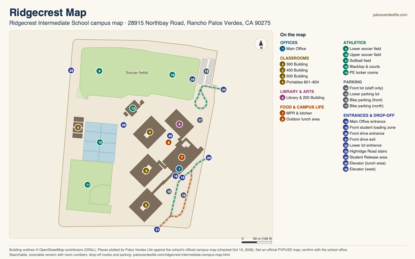
Find the office, a classroom or the fields
Find a place
A room's first digit is its building: 100s office, 200s library building, 300s–500s classroom buildings, 600s portables.
- 1Main OfficeOffices
- 2300 BuildingClassrooms
- 3400 BuildingClassrooms
- 4500 BuildingClassrooms
- 5Portables 601–604Classrooms
- 6Library & 200 BuildingLibrary & arts
- 7MPR & kitchenFood & campus life
- 8Outdoor lunch areaFood & campus life
- 9Lower soccer fieldAthletics
- 10Upper soccer fieldAthletics
- 11Softball fieldAthletics
- 12Blacktop & courtsAthletics
- 13PE locker roomsAthletics
- 14Front lot (staff only)Parking
- 15Lower parking lotParking
- 16Bike parking (front)Parking · approx.
- 17Bike parking (north)Parking · approx.
- 18Main Office entranceEntrances & drop-off · approx.
- 19Front student loading zoneEntrances & drop-off
- 20Front drive entranceEntrances & drop-off
- 21Front drive exitEntrances & drop-off
- 22Lower lot entranceEntrances & drop-off
- 23Highridge Road stairsEntrances & drop-off
- 24Student Release areaEntrances & drop-off · approx.
- 25Elevator (lunch area)Entrances & drop-off
- 26Elevator (west)Entrances & drop-off
Building outlines © OpenStreetMap contributors (ODbL) · basemap and satellite tiles © Esri. Place positions are Palos Verdes Life's own, matched to the school's campus map. OpenStreetMap draws the 300s, 400s, office and library buildings as one outline; we split it along its own lines so each building can be labeled. The office door, bike parking and Student Release pins are approximate. Campus details can change, so confirm with the school office.
Three loading zones: the front drive, the lower lot and the Highridge stairs
Front drive
- Turn in from Northbay Road at the front drive entrance.
- Follow the one-way drive southwest past the office; the school's map marks it a student loading zone.
- Leave at the exit onto Whitley Collins Drive. OpenStreetMap shows Whitley Collins divided there, so expect to turn right (west), toward Highridge Road.
The front parking lot beside the drive is marked staff parking only.
The other two loading zones
Lower lot: the school's map marks the lower parking lot, at the north end by the upper soccer field, as a student loading zone. Drive in and out on Northbay Road; OpenStreetMap shows a gate on the driveway, and when it's open isn't published.
Highridge Road: the map also marks a loading zone at the Highridge Road stairs on the west side, north of the portables. It doesn't say which side of Highridge to stop on.
Visitors & pick-up
All visitors, parents included, sign in at the front office, which faces the front loading zone. The school doesn't publish visitor parking. To take a student out early, a parent or guardian signs them out at the Attendance Office.
The map marks a Student Release area at the east end of the upper field, by the lower lot; it doesn't say whether that's for daily dismissal or emergencies, so ask the office.
The school day at Ridgecrest
| Tuesday–Friday | Time |
|---|---|
| Zero period | 7:15–8:10 a.m. |
| Period 1 | 8:15–9:10 a.m. |
| Period 2 | 9:15–10:10 a.m. |
| Period 3 (with nutrition) | 10:15–11:20 a.m. |
| Period 4 | 11:25 a.m.–12:20 p.m. |
| Lunch | 12:20–1:00 p.m. |
| Period 5 | 1:05–2:00 p.m. |
| Period 6 | 2:05–3:00 p.m. |
Other days & the office
- MondayZero period 7:15 · first period 8:15 · lunch 11:35–12:15 · out 1:55 p.m.
- Minimum dayFirst period 8:15 · out 12:15 p.m., no lunch period
- Main office(310) 544-2747 · attendance ext. 1 · fax (310) 265-1716
- PrincipalJaime Mancilla
Times are from the school's posted bell schedules and its 2026–27 student handbook, checked Oct 19, 2026. Ridgecrest is a closed campus from 8:15 a.m. to 3:00 p.m. Office hours aren't published, so call ahead. District key dates are on our schools page.
Three classroom buildings, a library wing and big fields
Classrooms by number
The first digit is the building. Rooms 101 and 102 are in the office building, and 202 to 206 share the library building in the northeast. The 300s, 400s and 500s fill three classroom buildings from south to north, and Rooms 601 to 604 are portables on the west side, with 601 nearest the Highridge stairs.
Library, MPR & lunch
The library sits in the northeast building. The multipurpose room and kitchen fill the rest of the office building, and the outdoor lunch area spreads between the office, the library and the 500 Building. The student handbook says hot lunches are sold in the cafeteria, and snacks and drinks at the snack counter.
Fields & courts
A big field along Crestridge Road holds the lower (west) and upper (east) soccer fields, and the softball field takes the southwest corner along Highridge Road. Basketball courts fill the blacktop between the portables and the classrooms, and the PE locker rooms are north of the 500 Building, by the fields.
Ridgecrest reopened its campus to students in September 2000 and is a 2026 California Distinguished School. The two elevator pins are where OpenStreetMap maps an elevator and the school's map shows an “E”; the map has no legend, so treat them as likely, not confirmed.
Bus, bike or car
Bus & bike
The school's handbook says bus service comes from Metro (MTA) or the Palos Verdes Peninsula Transit Authority, not the district; it lists PV Transit at (310) 544-7108, and routes and schedules are on PV Transit's site. Riders who bike or scooter need a helmet and a school registration sticker, issued after an online module on the California Highway Patrol's website.
By car
The campus fills the block between Highridge Road (west), Crestridge Road (north), Northbay Road (east) and Whitley Collins Drive (south). Both car entrances are on Northbay Road. Directions to 28915 Northbay Rd
Who goes here
By address, Ridgecrest serves every Soleado and Vista Grande address, in Rancho Palos Verdes and Rolling Hills Estates, plus the Montemalaga streets around Indian Valley Road and the Cartier, Marne and Rhone Drive area of the Point Vicente zone. Homes on the Avenida streets off Crest Road, Crest Road from 6653 to 6978 and Los Verdes Drive may choose Ridgecrest or PV Intermediate (every street). Our schools map shows the School Locator's answer for every address (checked Oct 3, 2026); confirm yours with PVPUSD's School Locator.
The school's own map, and how ours was made
Ridgecrest's official campus map is turned on its side: Northbay Road runs along the bottom and the fields are on the right. Ours is north-up, so Northbay Road is on the right (east) and the fields are at the top.
We don't copy the school's maps. Here are the originals:
- Official campus map from Ridgecrest (image)
- The same map as a PDF
- 2026–27 student handbook (PDF), which reprints the map on page 4
- Ridgecrest bell schedules
How we placed things
Building outlines come from OpenStreetMap contributors (ODbL). OpenStreetMap draws the 300s, 400s, office and library buildings as one connected outline, so we split it along its own lines, adding no new points, to label each building. We matched the school's campus map, a diagram that isn't to scale, to those outlines and to aerial imagery. The fields, courts and lots are placed by their own outlines; the office door, bike parking and Student Release area are approximate. The route on our map follows the arrows on the school's map.
Spot something out of date? Tell us.
Ridgecrest Intermediate campus FAQ
Where is drop-off at Ridgecrest Intermediate School?
The school's campus map marks three student loading zones. At the front, turn in from Northbay Road, drop off along the one-way drive past the office, and continue out onto Whitley Collins Drive; OpenStreetMap shows it divided there, so expect to turn right, toward Highridge Road. To the north, use the lower parking lot, in and out on Northbay Road. On the west side, use the stairs up from Highridge Road. Traffic rules can change, so confirm with the office at (310) 544-2747. Show the route on the map
Where do visitors park at Ridgecrest Intermediate?
The school doesn't publish visitor parking: its map marks the front lot staff parking only and the lower lot a student loading zone. Every visitor, parents included, signs in at the front office, which faces the front loading zone. Call (310) 544-2747 before you come. Show the office
What time does school start at Ridgecrest Intermediate?
First period starts at 8:15 a.m. every day. School ends at 3:00 p.m. Tuesday through Friday, at 1:55 p.m. on Mondays and at 12:15 p.m. on minimum days. Zero period starts at 7:15 a.m. Full bell times
Which elementary schools feed into Ridgecrest?
It goes by home address, not by school: every Soleado and Vista Grande address, the Montemalaga streets around Indian Valley Road, and the Cartier, Marne and Rhone Drive area of the Point Vicente zone. Homes on the Avenida streets off Crest Road, Crest Road from 6653 to 6978 and Los Verdes Drive may choose Ridgecrest or PV Intermediate. Check an address with PVPUSD's School Locator. On the schools map
How do I find a classroom at Ridgecrest?
The first digit is the building. Rooms 101 and 102 are in the office building, 202 to 206 share the library building in the northeast, the 300s, 400s and 500s fill three classroom buildings from south to north, and 601 to 604 are portables on the west side. Type a room number into the map's search to see its building. Search the map
Can students bike or scooter to Ridgecrest?
Yes, with a helmet and a school registration sticker, which riders get after completing an online module on the California Highway Patrol's website. Riders walk bikes and scooters to the bike parking; the school's map shows one area by the front flagpole and one near Northbay Road. Show bike parking